|
||||||||||||||||||||||||
 |
||||||||||||||||||||||||
| Technology |  |
|||||||||||||||||||||||
|
As a result of proprietary software development aimed at enhancing CLI’s performance in the underground facilities locating industry, CLI has created expansion opportunities from sources other than facility locating, specifically;
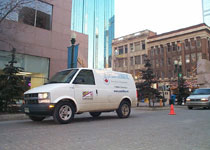
TECHNOLOGY IN ACTION As technology advances, we as a society are becoming more and more dependent on the services provided by buried fiber optic cables, power lines, gas mainline pipe, sewer, water and other facilities. CLI is in the business of locating these underground facilities for utility, construction, and other industries for the duel purpose of public safety and uninterrupted service. Management faced several challenges. There had to be a way to streamline operations, reduce the flow of large amounts of paper work, orders and a constant demand for a variety of different types of maps for different jobs. MODEL COMPARISON: HOW IT WORKS ‘BETTER THAN BEFORE’ Previously, field crew bosses had to come to the office and pick up a variety of maps (electrical utility subsurface maps provided by the electric utility company, the gas subsurface maps provided by the gas company etc.) in addition to the work order and so on. Things improved slightly with cell phones and pagers but the amount of work done was limited by these ‘communication’ factors. Rugged onboard computers were mounted in each vehicle. These ‘lap tops’ integrates wireless data communications that provide voice and document (words and maps) transmission. The on-board devices (essentially a lap top computer and a cell phone) capture real-time information from each vehicle, sending location data via a wireless link from the field to the dispatch office. CLI technician now leave home in the morning and head straight for the jobs site saving time from not having to report to the office. When a new ticket comes in, a CLI dispatcher in the central office logs on to an internet site (Locatorsbase.net) and receives all the required maps, the order any special instruction and so on. He or she enters all the required (the order, maps special information) information to the geographically closest CLI technician. (Usually job assignments are ready to go at the end of the previous work day but amendments can be made through the course of the day). In the field CLI technicians now receive work orders on their laptops via wireless link, enabling them to view maps and drawings of underground utility facilities (or whatever else management wants or needs them to see). Once on scene, the locator or technician uses a variety of sensors that penetrate the ground to precisely locate the position of underground facilities. The sensors are calibrated to emit an audio or visual signal when a buried pipe or cable reflects the (typically) radio signal at a certain frequency. That signal lets a locator know exactly where on the ground to leave his or her spray paint mark, along with any other necessary markings indicating what type of facility is below. If the technician locates a subsurface structure that is not where the engineering draws say it should be (variances arising from of ‘As Built’ vs. ‘As Designed’) the technician draws the amendments on his laptop. When finished, technicians send a message back to dispatchers indicating that the job is complete together with the file. Variations from “As Built” Vs ‘As Designed’ are automatically posted to a Clients particular web address allowing them to retrieve the new information and update their maps. This is a value added service for Clients at no extra cost. Over time, we improve a Clients data base or map base.
|
|||||||||||||||||||||||